Exploring Merritt 7: A Deep Dive into this Growing Area of Norwalk
From proposed development to major roadway infrastructure updates, there's a lot happening in the area in Norwalk around the Merritt 7 train station.
The northern section of Norwalk, near the Wilton town line, is home to the largest corporate office park in Fairfield County, thousands of residents, connections to major roadways, a small train station, and local businesses. Looking at a map, viewers can see Route 7 on the left, Main Avenue on the right, Grist Mill Road at the top and the Merritt Parkway at the bottom.
There are also major plans for the area, which call for new housing and retail, improved roadways and traffic flow, upgraded pedestrian and bicycle infrastructure, the route for the Norwalk River Valley Trail, and a newly renovated train station.
“A village effect.” That was how Norwalk Mayor Harry Rilling described the plans for the area around the Merritt 7 train station when he toured it with Gov. Ned Lamont in 2021.
With many of these projects in the works, or beginning soon, let’s dive a little deeper into the plans for this region of Norwalk.
Upgraded Train Station
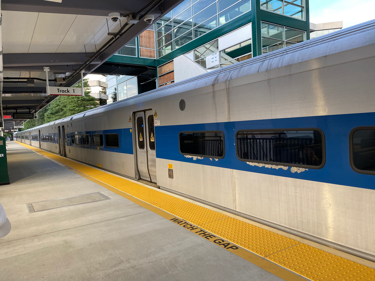
At the heart of the area is the Merritt 7 Train Station, which is on the Metro North’s Danbury line. The station, neighboring roadways, and parking areas have gone through an approximately $20 million upgrade over the past few years.
The new boarding platform, which is now raised to meet the train cars instead of having customers step down and out of the train and includes covered canopies, opened on June 7, according to CTDOT Spokesman Josh Morgan.
“The new station will include bike racks and EV chargers, and additional vehicle parking,” Morgan said in a statement. “Additionally, as part of this project, we’ll be striping bike lanes along Glover Avenue within the project area limits.”
Morgan said that currently paving is taking place on Glover Avenue, as well as the parking lots around the train station.
“The paving is being staggered to ensure there is adequate vehicle parking available,” he said.
But one of the biggest additions will be a pedestrian bridge, connecting the station—and the townhouses, apartments, and offices around it—to the Merritt 7 Office Park and Main Avenue. This allows those who take the train a faster, safer way to get across the train tracks which run between the two. However, that part of the project has been delayed, according to Morgan.
“The glass and materials needed to enclose the up-and-over crossing has been delayed,” he said. “We cannot open that crossing until it is safe to do so. The expectation is for the pedestrian bridge to be completed in the coming months, and the new Merritt 7 station to be fully opened by the end of the year.”
While the station itself has been improved, service is still much more limited than the main stations served by Metro North’s main New Haven line.
During the weekday morning peak, which runs from 6 a.m. until 9 a.m., four direct trains leave Merritt 7 for Grand Central and another train ends in South Norwalk, In the evening peak hours, which run from 4 p.m. to 8 p.m., three direct trains travel from Grand Central to Merritt 7, with an additional two trains that run from South Norwalk to the station. Just two trains travel to Danbury before 10 a.m., during the week, and on the weekends, trains depart for South Norwalk or Danbury every three hours.
For comparison, East Norwalk, which is a smaller station than the hub of South Norwalk, has 10 direct trains to Grand Central in the morning peak hours, with 11 direct trains from Grand Central in the evening peak hours.
Still, officials said that the station is at the heart of the plans for the region, particularly the North Seven planned development.

Plans for North Seven: Apartments, Retail, Parks
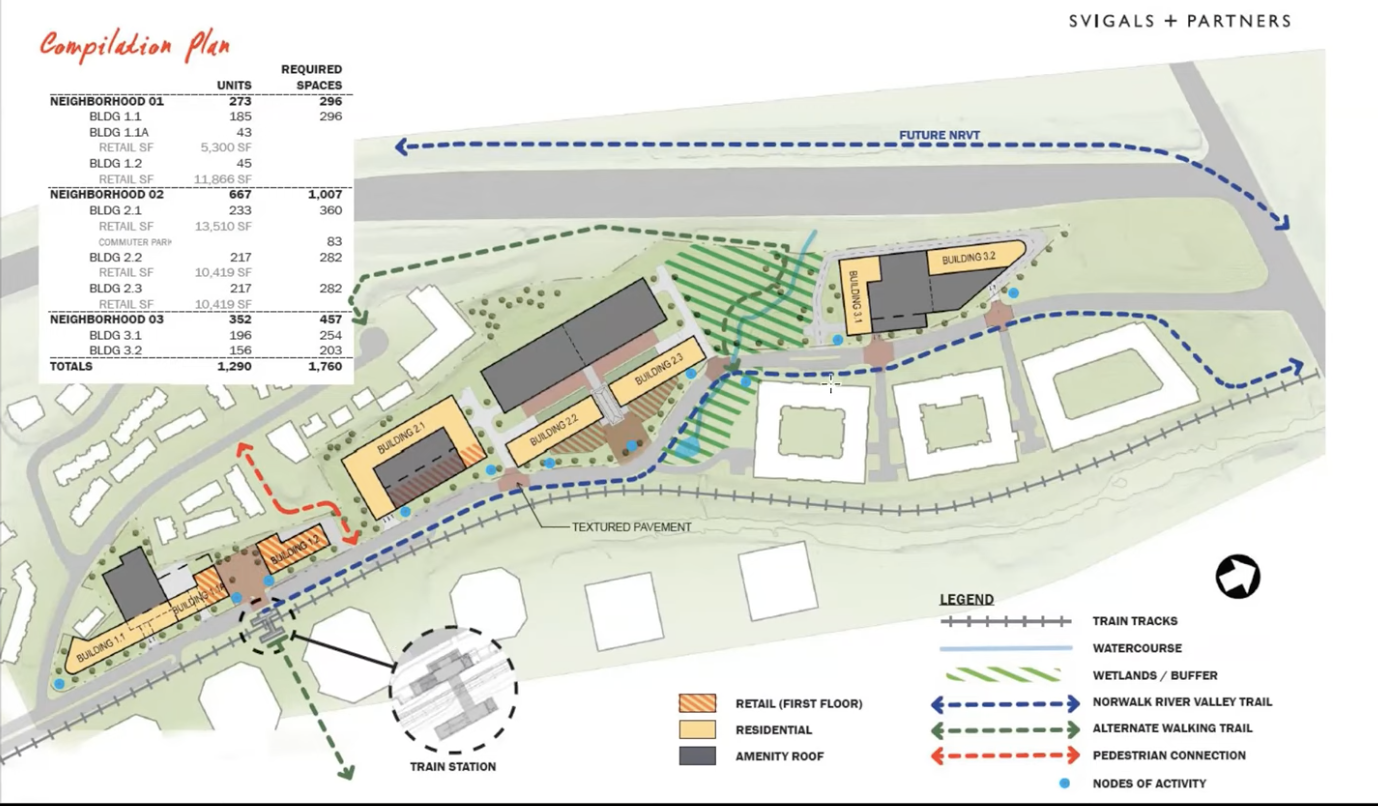
The area has already seen some development with the construction of the Curb Apartments, which opened in 2019, and the One Glover Apartments before that, in addition to multiple townhouse and condo buildings. But the newest plans for the area call for potentially bringing about 1,290 new apartments across seven buildings, 50,000 square feet of retail, additional infrastructure improvements, and a small 2-acre park.
So far, Norwalk’s Planning and Zoning Commission approved the overall plan for the area, but for each phase, the developer will have to submit a site plan application, which would provide specific details about the architecture, engineering, traffic, and more for that specific piece. Phase 1 is the only part of the project that can be logistically constructed at this time, according to the developer and the conditions the commission put on the plan’s approval.
Phases 2 and 3 are contingent on improvements to local roadways from Connecticut DOT. Phase 2 is contingent on the proposed improvements to the Route 7–Merritt Parkway–Main Avenue interchanges, while Phase 3 is contingent on improvements to Grist Mill Road and Route 7.
“We’re proposing a town square, right across from the train station,” Attorney David Waters, representing the developer Building and Land Technology, said at a June 2022 Planning and Zoning Commission meeting. “This is viewed as being the center of the development, with retail on either side as a gathering space, as a place where events can take place, as a place where just a general identity can occur.”
Phase 1 calls for constructing Building 1.1, Building 1.2, Building 2.1, the proposed “town square,” and streetscape improvements along that section of Glover Avenue. That would include about 500 housing units, more than 700 parking spaces—including 83 for commuters—and more than 30,000 square feet of retail space.
The approval from Norwalk’s Planning and Zoning Commission also requires the applicant to “submit an application to the CT Department of Transportation” to add a sidewalk running along Grist Mill Road, which would connect Glover Avenue to Main Avenue, along with additional improvements, such as a crosswalk at that intersection.
“We wanted these to be the first three buildings because they’re around the train station, they support the community, and they also include the commuter parking fo the train station,” Waters said, adding that the developer “would be able to do that relatively immediately with very little impact on the traffic end of things.”
But that would not be the case for the next two phases which Waters noted would require “significant offsite traffic improvements to the region and to the area.”
Phase 2 would be Buildings 2.2 and 2.3, along with streetscape improvements for that area. That would include more than 425 housing units, more than 550 parking spaces, and about 20,000 square feet of retail space.
And Phase 3 would be Buildings 3.1 and 3.2, Raccoon Park, walking trails, and the remaining streetscape of Glover Avenue. That would include about 350 housing units and about 450 parking spaces.
Waters did note that the plan was “flexible” in case there was a desire for a building to be turned into a hotel or if a company like Google wanted to make a mini-campus there.
BLT has already tried to bring some activity to the area with Junction North Seven, which brought some pop-up food trucks, craft beer, and more to one of the buildings across from the train station. But the effort fizzled out by 2020 and nothing else has reopened there.
The proposal, called North Seven, comes from Building and Land Technology, which is also the developer of Stamford’s Harbor Point. The company has come under scrutiny for its work in Stamford, where it is the largest developer, following a patio deck collapse at its Allure building and a lawsuit filed against the company by Gaia Real Estate.
Gaia purchased five buildings in Stamford from BLT in 2016, including The Lofts, which was a 225-unit development at the converted Yale & Towne lock factory. Engineers and architects found that the building was sinking and moving sideways, due in part to a liner BLT installed to cap the contaminated soil. The lawsuit “alleges that BLT prevented its surveyor from viewing certain substructures before the purchase; that BLT did not test the capacity of the wood pilings; and that BLT withheld records of soil tests taken in 2010, the year BLT completed construction,” according to CTExaminer.
Still, the developer said that it is planning to bring its Live, Work, Play environment to the area to support the offices at Merritt 7 and in the surrounding area, such as ASML in Wilton.
“The plan itself—it is proposed to be predominantly residential in nature,” Waters said. “If you look at it in a vacuum it really is almost all residential in nature. If you look at it in conjunction with what’s around it, it counterbalances what’s around it—2 million square feet of office.”
Waters noted that 5% of the overall city tax revenue came from about 15 buildings in the area—the Merritt 7 Office Park, a few properties on Glover Avenue, and a few on Main Avenue.
“What Class A [office] tenants are looking for now are experiential environments—the live work play,” Water said. “We can support the economic engine of Norwalk and create this as a transit-oriented development environment that works.”
Connecting the Merritt Parkway
As we’ve previously highlighted, CTDOT recently presented its plans for connecting Route 7 directly to the Merritt Parkway in all directions—right now, drivers can only get to the Merritt Parkway South towards NYC from Route 7. Main Avenue, which runs pretty much parallel to Route 7, has connections to the Merritt Parkway in both directions, but those connections have had the most accidents on the parkway in this region.
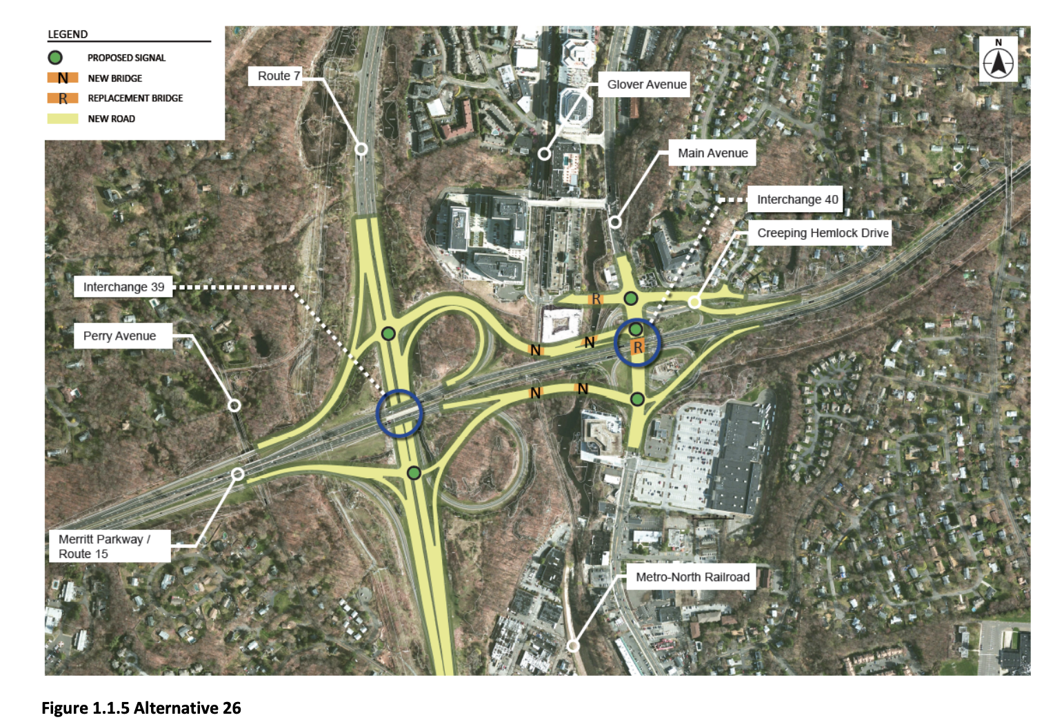
That’s why officials said one of the goals of the project is to connect Route 7 directly to the Merritt Parkway and eliminate those tight ramp loops on Main Avenue. Alternative 26, which is the state’s preferred plan, would create a connector road from Main Avenue to Route 7 to the Merritt Parkway and add two traffic lights to Route 7 at those intersections.
“The existing Main Avenue and Route 15 Interchange ramps have substandard acceleration and deceleration lanes, steep changes in grade, sharp curves, and limited sight distance. These factors contribute to a high number of crashes,” the environmental impact report for the project stated.

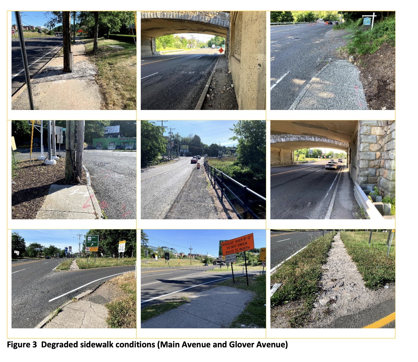
The state’s recommendation, Alternative 26, would bring significant pedestrian and bicycle infrastructure improvements to the Main Avenue corridor. Right now, officials noted that the area lacks sidewalk connections, particularly around the Merritt Parkway entrances and no bike lanes, making it very unsafe.
“Bicycle and pedestrian facilities in the project vicinity are limited, despite substantial pedestrian activity during the weekday midday time period in the vicinity of the office buildings on the west side of Main Avenue,” according to the environmental impact report. “There are no bicycle facilities in the study area, and shoulder widths are less than one foot wide on Main Avenue.”
State officials said that by adding these infrastructure upgrades, the environment would be safer for all users.
“The improvements would provide safer bicycling and walking conditions to access transit, local businesses, and places of employment,” the report noted. “Both alternatives would facilitate connections to the planned bike lane improvements on Glover Avenue and the new Merritt 7 train station. These improvements would likely induce more pedestrian and bicycle trips by improving access to these destinations.”
Waters said that these improvements will include ”a significantly enhanced sidewalk system” in that area and major upgrades to the Glover Avenue–Main Avenue intersection which will enhance the whole area. That intersection is one way in and out of the developments that currently exist behind the Merritt 7 Office Park and the proposed North Seven development.
Improving Grist Mill Road
The Merritt Parkway proposal has taken years—even decades—to get where it is today, but officials are hoping to start construction around 2025. Once that is completed that would allow Phase 2 of North Seven to begin.
Even farther down the line is a proposal to address the traffic flow at the northern end of the area. Right now, the Route 7 limited highway ends with a traffic light at the intersection with Grist Mill Road.
An early design proposal from CTDOT would realign that intersection, connecting Glover Avenue directly to Grist Mill and connecting Route 7 in Norwalk to Main Avenue and the rest of Route 7 running north to Danbury.
“This proposal would change it into a four way intersection,” Waters said, which would allow for a “free flow of traffic to Main Avenue.”

But this plan is very early in the concept stages and as Waters noted it is “not yet carved in stone that this is the answer.”
What about the Norwalk River Valley Trail?
So far we’ve highlighted connections primarily for drivers and those who use the train to get around. This region also will feature another connection primarily for pedestrians and bicyclists—the Norwalk River Valley Trail.
The planned 30-mile trail is proposed to run from Calf Pasture Beach in Norwalk, all the way up to Danbury, passing through towns like Wilton and Ridgefield along the way. The trail is being constructed in parts, with a major section currently completed in Norwalk—from Calf Pasture Beach up to Riverside Avenue—and a large section finished in Wilton.
But how the trail connects between those two segments is currently a little bit of a question.
According to the 2012 Norwalk River Valley Trail Routing Study: “In Norwalk, the primary route follows the west side of Route 7 within the right-of-way southward and under the Merritt Parkway. The recommended secondary route runs east of Route 7 and connects to the Merritt 7 train station.” That would route the trail under Perry Avenue.
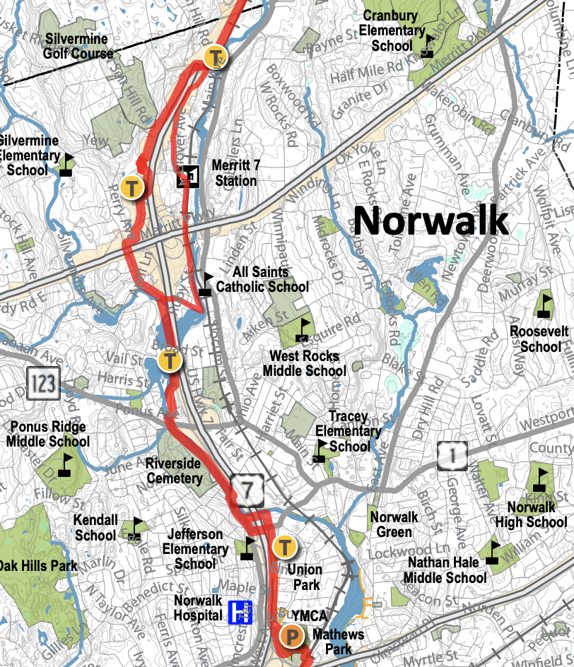
Officials have talked about creating a spur or path off the NRVT to connect to the Merritt 7 station to allow pedestrians and bicyclists using the station to connect to the NRVT.
But local biking and walking advocates said that they wanted to see the Norwalk River Valley Trail routed through the Main Avenue–Glover Avenue area.
Resident Ben Hanpeter, who said at the Merritt Parkway–Route 7 hearing that he rides his bike to work in Wilton from his home in South Norwalk and is very familiar with the area, said that NRVT will “one day make up the backbone of the whole region’s bike network.”
“But a chain is only as strong as its weakest link,” he said. “The current proposed route on Perry Ave will put trail users in with mixed traffic, and I think that will make it a much less attractive option for a lot of people.”
The trail has seen use skyrocket during and coming out of the COVID-19 pandemic, with some trail counters documenting a 200% increase in people on the trail. Advocates say that it would provide a vital link, not just for recreational purposes, but essential transportation between South Norwalk and Wilton, where many people live, work, and go out.
Impact to Existing Residents
While there are many plans outlined for the future of this area, there are also many residents who currently live in the area and will be affected by the work taking place.
Heather Dunn, who is running as an independent candidate for Common Council and is the current president of the Silvermine Homeowners Association, emphasized the need for coordination of all of these projects to try and mitigate effects in the region when she spoke at the Merritt Parkway–Route 7 public hearing.
“My biggest concern is that we are getting slammed in Norwalk,” she said. “I just want to make sure that, as much as it can be, 95 is done being constructed. I know there’s another project for Grist Mill to be continued on which is a separate DOT project group, and It doesn’t seem like there’s a lot of coordination and timing. We have the Walk Bridge being constructed. Norwalk really needs help with coordinating that so it’s not happening all at once for us.”
Other residents spoke out at Norwalk public hearings against the plans for North Seven, particularly raising concerns over traffic and other stresses on city services, like police, fire, and the school district.
“Has anyone actually looked and walked up and down Glover Avenue?” resident Elizabeth Lazarou asked at the June 2022 public hearing for North Seven, adding that this development would add to the “accidents waiting to happen.” “I can’t conceive of adding more traffic.”
BLT’s team did an economic analysis as a part of their application, which said that the development would be a “fiscal positive for the municipality,” providing an estimated $2.3 million more in tax revenue than expenses in addition to one-time boosts to the city’s economy like permitting fees and construction jobs.
The report also noted that the development would be transit-oriented and “build upon the existing transit service in the region.”
“We seem to be building a third center for Norwalk, and we already have two centers—I don’t think we need a third center,” resident Leigh Grant said at the public hearing for the North Seven plans.
How do I stay informed?
While these plans and proposals are all connected, separate entities are in charge of each of them, so here’s a list of places to learn more about all of these projects.
- North Seven Development Plans (from the City of Norwalk)
- The Route 7/15 DOT Project (from CTDOT)
- Norwalk River Valley Trail (from the NRVT)
Editor's Note: This article has been updated to note that the pedestrian bridge will go over the train tracks, not the Norwalk River as previously stated.